Sunday 31 March 2019

A -60ºC emergency rescue

If someone has a medical emergency, the logical reaction is to call an ambulance. In a small village, in the worst case, the ambulance must come from a larger town. Then, you would have to wait between 5 and 15 minutes for the ambulance to come. But what do you do if you really need an ambulance and you're in the South Pole in the middle of the austral winter?

In June 2016 a medical rescue expedition was made to evacuate two ill workers from the Amundsen-Scott station, located exactly at the geographical South Pole. I would like to point out that these days, in the northern hemisphere, you were enjoying the longest days of the year and, therefore, in the South Pole, they were in the middle of the austral winter. This means 24 hours of absolute darkness and, the feeling that if you are at -50ºC, you're enjoying a warm wave.

But before explaining how the two patients had to be evacuated, let me explain how life is at the Amundsen-Scott station.

The first building of the Amundsen-Scott base was built, exactly in the geographic South Pole in 1956. The base obviously bears the name of the first two expeditions that reached the South Pole: the first one, the Norwegian expedition, leaded by Roald Amundsen, followed some days later by Captain Robert Falcon Scott's British expedition which, apart from losing the race, ended up in misfortune, dying all the components of the expedition of famine and cold on the return journey.


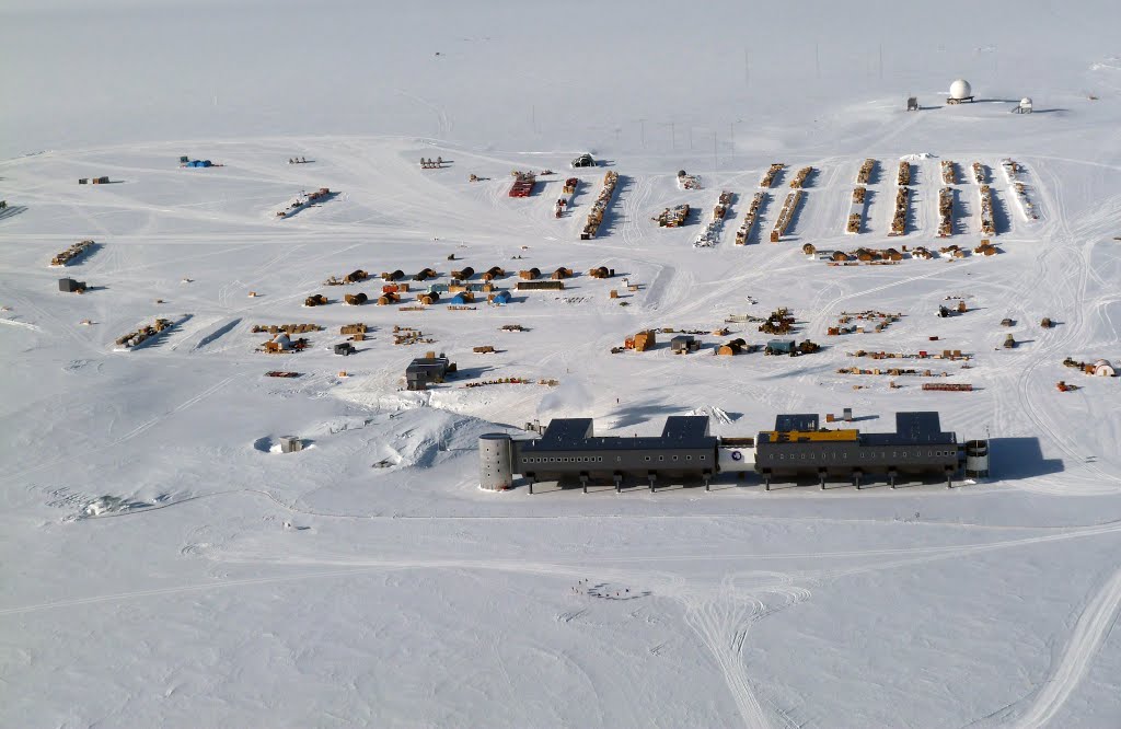
After successive extensions, demolitions and remodelings, the base is currently made up of a main building (the gray one, in front at the photo), and a whole series of small auxiliary buildings that perform as laboratories, workshops... If you look at the image, in the foreground just in front of the main building, you will see a small half-circle shaped by what might look like poles or stakes. In fact, they are the flags that enclose the exact point that, at that time, occupies the Geographic South Pole. And I say "at that moment" because the Base is located on a giant glacier that moves about 10 cm. each year. So, from time to time, they need to dismantle the whole thing and re-place it on the right place.


The current building, the gray one on the photo, is quite interesting. Do you see that it is suspended over a kind of pillars? Here you can see it better:


These pillars are hydraulic and can be raised up to twenty centimeters. As ice moves, there could be different settlements throughout the building. When this happens, the height of a pillar is extended or decreased and problem gets solved.

The other curious point is this sloppy lower part of the building (just above pillars' head). This is intended to use wind when blowing. The air is forced to divert below the building and, when following this path, the wind accelerates and helps the recent snow to get cleaned from below the buildings. You might think that the South Pole has a very dry climate (it is really far from the sea), and receiving only around 20cm per year, snow shoudn't be a problem. But this snow never disappears; It always accumulates. If fresh snow under the buildings doesn't get removed, in a few years they would be buried!

The base has all kinds of comforts for almost 200 inhabitants in the summer, and 50 in the winter: gym, sports field, library, games room, cinema, greenhouse, a small hospital. Seems not so bad ...

Standard bedroom at the Base

At the shop you can buy clothes, food, sweets, alcohol and, also, rent a DVD.

Sports court is also used as a conference room.

Dining room with Christmas decoration... during austral summer, of course!

Here you have a video with a promenade inside Amundsen-Scott Base:


Life conditions, however, are very hard. And especially for the fifty or so people that stay there during winter season. The average temperature during april to septemeber is... -60ºC. And this is only the average, because it's quite easy to go below -70ºC (lowest ever recorded temperature was -82,8ºC). Would you like to know what do you need to wear for these temperatures? Watch it in the next video:


But coldness isn't the worst thing (you should already know that cold weather is never a problem in this blog). The worst is that, during anctartic winter, Amundsen-Scott Base "enjoys" 6 months of absolute night and darkness. Yes, This is the only point on the planet that, every year, only has one dawn and one dusk. It means that every year, around mid-March, the sun goes down and doesn't gets back until mid-September. On September 21st, the first day that the sun appears, it will stay permanently in ths sky until next March.

Fantastic! Temperatures around -60ºC and total darkness. And when a say total darkness means.... total! There's no luminic contamination in a circle of 2.000km so sky is dark black with thousands of stars. For the 50 braves that "hibernate" at the Base, the psychologic challenge is really harsh. Moreover, they are almost totally isolated, except by phone and internet. Basically all hibernants are workers that maintain the Base, and some scientists that need to do their research during austral winter.


And what about the rescue mission? In May 2016, two hibernants felt ill and couldn't be treated at the basic Base hospital. The only way to save their lifes was evacuation. The first problem was how to find a plane capable of landing in such conditions. Usually, the route is served by New Zealand planes, but they are only prepared for summer flights. If they wanted to find planes (and pilots) with the capability for that flight, they should search in.... Canada!

Kenn Borek Air is, probably, one of the more "extreme" airlines of the world. Their main specialty is flying the Canadian Arctic routes, so they owned two Twin Otter planes prepared for temperatures below -70ºC. Both bimotors took off from Calgary, Canadà and, one week and 16.500Km later, one of the two planes landed at Amundsen Scott Base, picking up both patients. Whatch the conditions under which the rescue took place:


Although the small inconvenients that staying a winter in Scott-Amundsen Base has, belive me; if I got the proposal of going there, I would pack my suitcases immediately!

Sunday 25 June 2017

The other final

Bhutan and Montserrat Island; what these two places could share in common?
 
Bhutan is a small independent country (one of the few in Asia that has never been a colony) in the middle of the Himalayas, between India and Tibet. It is an odd country; only 700,000 people living in several valleys on the south side of the eastern Himalayas.


Unlike Tibet and Mustang (see post), as Bhutan is located at the south side of the Himalayan range, Monsoons have no impediment to release liters and liters of rain every year over Bhutan. This makes bhutanese scenery remember the Alps, so yes, you'll easily hear everywhere that "Bhutan is Himalayas' Switzerland". But today, this won't be the main topic...


For me, the main curiosity of Bhutan is the strange system of government they have, and what this has meant in its recent history:

Until the early twentieth century, Bhutan was a country of quarrelsomes. Warlords were not only fighting eachothers in ongoing civil wars but, from time to time, they felt brave enough to attack India's British colonial Army. Every time Bhutanese challenged the Brits, they ended up losing, beaten and forced to pay a tribute to her Most Gracious Majesty... until they stopped paying, grabbed swords again, and got defeated in a testosterone never ending cycle.


At the beginning of the twentieth century, a "Ponlop" one of the country's warlords, was able to defeat his rivals, he befriended the British and proclaimed himself king of the country. Thus, Ugyen Wangchuk was proclaimed Druk Gyalpo, meaning "Dragon King". You will see the dragon ("Druk") is an omnipresent motto in Bhutan. It was said that the highest mountains of the country were the dwelling of the Thunder Dragon, so they ended calling their country "Druk Yul"; the "Land of the Thunder Dragon. "
 

Wangchuk family continued to reign and, during the 70s, King Jigme Singye Wangchuk began a modernization of the country based on, what he liked to call, the GNH (Gross National Happiness) instead of GDP (Gross Domestic Product). The GNH concept is based on promoting the happiness of the population over the typical economic growth. A real 70's hippie-style concept. At the same time, they enacted laws to limit cultural Western influence and thus promoting Bhutan's traditions and way of life.


Indeed, the influence of King Jigme Singye Wangchuk's guidelines marked the character of modern Bhutan: the quality of life is quite correct considering it's a 3rd world country and it doesn't correspond at all with country's position in the GDP ranking. It is also curious how these rules ensured the maintenance of Bhutanese culture and traditions. For example, public administration workers are required to always wear the bhutanese traditional dress!

Men's socks reaching the knee is a British colonial influence imported from India


Nowadays King, Jigme Khesar Namgyel Wangchuk and his father, King Jigme Singye Wangchuk

Now let's forget the Himalayas and focus on the island of Montserrat: This island is located along the eastern Caribbean. It is an English colony, with about the size of Formentera (the smallest and less known of the Balearic Islands) with only 5,000 inhabitants. It's a paradise island, lush and green but has a major drawback:


In 1995, after centuries of inactivity, the Soufriere Hills volcano erupted. The activity of the volcano, although it has declined in recent years, has not stopped and has obliged the southern half of the island to be abandoned. The capital's airport, port and many other island's key places have been moved up north. Obviously, the economy of Montserrat, closely linked to tourism, has been greatly affected. Meanwhile, many residents of the island (should them be called "Montserratians"?) have emigrated to the colony metropole: United Kingdom.


One of the main Montserrat Island's economic activities maybe still remain in the memories of pop and rock enthusiasts, especially those of my generation. During the 80s, one of the most famous music producers in UK, George Martin (known as the "fifth Beatle") set up a recording studio, the AIR Studios on the island of Montserrat. 80's bands such as Dire Straits, The Police, The Rolling Stones and Pink Floyd recorded their albums on the island of Montserrat. If you still keep British artists vinyl albums from the 80's, look at the credits. In many of them, you will find:"Recorded at AIR Studios, Montserrat."

Dire Straits in Montserrat, while recording Brothers in Arms album

So what ties a small Buddhist kingdom in the Himalayas and a Caribbean island? And no, it's not  (only) men wearing high socks!

Answer is football. More specifically an exceptional match. An all-or-nothing final game. Bhutan and the Island of Montserrat face to face in a historical match to decide which was ...

...the Worst National Team of the World!

In 2002, the World Cup was held in Korea and Japan. In this edition, Dutch National Team failed to qualify for the Cup so, sad and frustrated, Matthijs de Jongh, a Dutch documentaries producer, decided to organize a match between the two teams ranked last in the FIFA ranking. At that time, the 202th position was occupied by Bhutan and Montserrat was the last one, ranked 203th. De Jongh got in touch with both national federations and, together with a Japanese film producer, organized the match.


Both countries welcomed the match with unbridled fervor. Due to the Soufrière volcano still creating some problems, it was decided that the match would be held at the Changlimithang Stadium, in Thimpu, Bhutan's capital. Both teams trained hard for months. Until then, neither team had not won an official match ever. In fact, Montserrat had never won even an unofficial match. In the case of Bhutan, they had been able to win a friendly match: they had won the powerful (not officially recognized) Tibet National Team (if you don't know anything about football, this was irony!). So, both teams had a ludicrous curriculum.

Bhutanese National Team

Montserrat's National Team

I wouldn't say I am a big football fan, but I must admit that football, if well managed, can have a unique capacity to unite, inspire and create incredible bonds. And that's what happened because of this match, so called "the other final" and held a few hours before, some thousands of kilometers away, Brazil and Germany played 2002 World Cup Finals.


The match ended with a clear victory for the Bhutanese: 4-0. It should be said that, because of food poisoning, Montserrat had seven losses. However, Bhutan dominated the match from beginning to end. This confrontation allowed bhutanese striker Wangay Dorji, to become Bhutan's all-time best player. That night he scored three goals; together with the two goals scored the following year against Guam National Team, made him become the leading scorer in the history of Bhutan Team, with a global mark of... five goals! This is an incredible feature if you consider that the Bhutan standings show, nowadays, a gloomy 31 goals scored versus 220 goals received in 5 wins, 4 draws and 51 defeats in Team's history).


The game ended with the delivery of a very original trophy: a cup that was divided into two equal parts, one for each team. Despite the defeat, Montserratians (?) fought until the last minute, and ended the match very proud about themselves and how they had played. Moreover, the whole experience and the warm and friendly hosting in Bhutan, would be long time remembered in Montserrat.


Wangay Dorji (10) Bhutan's top scorer and Charles Thompson (2), Montserrat's captain.

Since that "final" was played, both teams have improved a lot. This year, Montserrat is ranked 178th (of 209 members) in Fifa ranking. Bhutan, has reached 166th position!

If you would like to watch the documentary "The Other Final", you'll find it easily on Youtube.

The passion for football ended up joining two countries located more than 14.000km from each other. Apparently they had nothing (except long socks!) in common but a ball can do miracles!


Sunday 8 January 2017

The Great North (2): One IKEA and two New Year's Eve

I guess for many readers, the idea of spending the whole Saturday at Ikea will cause them an anxiety attack and  an uncontrollable need to flee. To me, despite my passion for all that is Swedish, my blood runs cold when my wife says resignedly: "On Saturday, I fear that we will have to go to Ikea". Thousands of people, children running around between "Bjursta" tables and "Sultan" beds, and couples discussing whether it is better an "Ektorp" or a "Beddinge" sofa...

But what's the relation between remote and isolated places, and crowdy Ikea warehouses? Maybe for you, the Swedish furniture store is a nightmare, but there are people who consider Ikea as the best destination!

At the Gulf of Bothnia northern end, in the Baltic Sea, the Scandinavian Peninsula merges the European continent. The border between Scandinavia (Sweden) and the mainland (Finland) is marked by Torne river (in the map above is written in Swedish: "Torneälv"), that runs from the coast, northbound to Kiruna surroundings (see the first post of the series). At the same point where Torne river flows into the Baltic, there is a city; well, actually two cities; no wait, it's just one, Oh! forgive it!. People on the east bank of the Torne River lives in a town called... Tornio (long live originality!) that belongs to Finland. The town on the west bank of the river belongs to Sweden and is called Haparanda (Swedes are so creative!).


I said the fact whether it was one or two cities because, originally, it was a single village. For many centuries, Finland was part of the Kingdom of Sweden and the city of Tornio (in Finnish), or Torneå (in Swedish), was a prosperous city, considered the center of all trade with Lapland. Even there are some historians who assert that, during the 17th century, the town was the richest in Sweden, despite its few half thousand inhabitants.


Sweden's defeat at war against Russia in 1808, made Finland fall into the hands of the Russians. By desire of Czar Alexander I, Tornio went on Russian Empire's side. But as border was established in the Torne river, and there were houses in both sides of the river, a small part of the city remained on the Swedish side. So the Swedes gave to this few houses that remained in their hands the name of Haparanda.

Russian laziness made the once prosperous Tornio fell into utter decay; and neigbouring Haparanda was too small to be able to prosper alone. With Finnish independence achievement in 1917, the situation did not improve much, and it was not until after the Second World War when Tornio's economy improved, especially thanks to the production of the successful local beer: Lapin Kulta.

  
But make no mistake, at the beginning of the 21st century, both twin towns, Tornio and Haparanda, did not offer many opportunities for young people. Many people was leaving towards the south, either Sweden or Finland, for studying or just to look for a better job. And this depopulation was not only happening in the main two cities; all region was losing inhabitants year by year. 


In the early 2000s, Haparanda's mayor, Sven-Erik Butch, had an idea. It could seem a foolish idea for those living far from the Arctic Circle, but for him and his team was full of sense. The mayor was able to contact Ingvar Kamprad, Ikea's owner, and asked him only one question: "Take a map of the Nordic countries, put it upside down, and tell me what you see" said Sven-Erik. So did Kamprad, realizing that lots of people, distributed in four countries (Sweden, Finland, Norway and Russia), had no access to any Ikea. 


On November 15th 2006, more than 5,000 people lined up neatly (as always in Sweden!) under a heavy snowfall, waiting for Ikea Haparanda's doors opening for the first time. Success was immediate, and in some months, Torne river commercial area attracted many more stores: I-Huset, Haglöfs, Candy World ... many brands found that the Arctic was a fantastic market! 


But, the economic potential expected by Mayor Sven-Erik Butch, was it real? Yes. Following the success of Ikea Haparanda, experts analyzed what the population of Arctic Circle represented as a consumption market. After the Ikea experience, however, survey showed the market was not splitted by borders; they analyzed the entire area population, no matter if people were Swedish, Finnish, Norwegian or Russian. And so, studies showed that there is a population of nearly 1.5 million people eager to buy, just as any European would, with the only difference of long distances. No matter in which country are they living, and in which country are sold the goods to be bought. If you look at the parking lot of Ikea Haparanda, any regular day, you will notice a difference when comparing with the rest of Ikea around world: it's full of coaches! Coach plates (and also car plates, of course!) show people come from every corner of the Great North to Ikea Haparanda. Many coaches leave early in the morning from remote locations, either in Arctic Russia, Norway, Sweden or Finland, full of Arctic inhabitants ready to travel more than 400km, and buy in Ikea. Then, at dawn, they get back on the bus and travel back home, maybe for more than 5 hours. Seems crazy, but Haparanda's Ikea has been able to revitalize the economy of both cities and stop their depopulation. 


Oops! And the two New Year's Eves from the post's title? It's simple: Haparanda-Tornio is one of the few cities (well, I do not know any other) that are separated by a border ... and in two different time zones! So, while Sweden uses CET (Central European Time, or UTC + 1), Finland is located in EET (Eastern European Time, or UTC + 2) zone. And this allows that each New Year's eve, people celebrates the first midnight 12 strokes in Tornio, and then, they cross the border and celebrate again a New Year, just one hour later, in Haparanda! 


As you can see, Tornio and Haparanda enjoy a very good relationship, and it's getting closer and closer. Gradually, both cities started to share municipal services, institutions and schools and now, they even share a golf course located in the border. So finally, they have decided to go one step further and become (legally) a single city. And how are they going to call the new merged town? Tornio-and-Haparanda? Haparanda-Tornio? None of these! Flaunting of great creativity skills, both cities have decided to get renamed (oh, my God!) as EuroCity! 

Thursday 29 December 2016

Celts that came from afterlife


In this post, I'm going to change from usual remote geography topics to linguistics topics, or rather "remote linguistics". I'll start writing about an European language that has the impressive amount of.... 700 speakers: Cornish.
 
But what is most impressive about this language is that it has returned from afterlife! It was completely extinguished, and now has reborn!

Let me travel a lit bit back in time. Just mere 2,500 years ... At this time the Celtic languages dominated Western Europe. They were divided into two groups:

  • Continentals: among others, Celtiberian from the Iberian Peninsula, Lepontic language from southern Switzerland and northern Italy, and Gaulic (or Gaulish) from Gaul,... yes, Asterix and Obelix obviously did not speak anything remotely similar to French. They spoke a Welsh related language that became extinct before year 600 DC.
  • Insulars: Irish Gaelic, Scottish Gaelic, Welsh, Breton (Hey! Brittany is in France so not an island and should, therefore, be a Continental Group language...). Other languages, as Cornish and  Manx are also Insular Celtic.

    The Romans arrival, and some years later the invasions of Franks and Goths (in Continental Europe), and Angles and Saxons (in Britain), shelved these languages that formerly had dominated Western Europe for centuries. The Lepontic language disappeared, and so did Celtiberian and Gaulish. Britonnic took refuge in France becoming present-day Breton (nowadays 200,000 speakers) and that's why, even being spoken in France, so "Continental" Europe, Breton belongs to the Insular Group, as its ancestor is "Insular" Britonnic. Other Celtic languages, as Irish and Scotish Gaelic, struggle to survive, and only Welsh resists the attack, but suffering a lot.

    And a similar fate suffered Cornish:

    Cornish language was spoken in Cornwall, which is the region located in the southwesternmost point of the Great Britain island.


    Cornish was a close relative of Britonnic, the language spoken in England when Romans arrived. And, therefore, related also to Breton, currently spoken in Brittany, France (Brittany, before Bretons migration was known by the Romans as Armorica, and there was where Asterix' village).


    Around year 1300, Cornish reaches its moment of maximum splendor and extension. But in the sixteenth century, the British government decided to create a law, the Act of Uniformity that aims English as lingua franca, role played until this moment by Latin. That law shows that English government was aware that, in Cornwall (and also in other parts f the kingdom), there was a large part of the population not able to speak a single word in English,... so they were Cornish-only speakers. In a report addressed to King Edward VI in 1549 is said:

    "In Cornwall is two speches, the one is naughty Englysshe, and the other is Cornysshe speche. And there be many men and women the which cannot speake one worde of Englysshe, but all Cornyshe."


    The new law did not try to remove Cornish language(or Welsh, Scots or ...) but since 1400, Cornish was already losing speakers. English language pressure was harassing Cornish to the west.


    It is considered that Cornish language disappeared completely during the eighteenth century. But a quite big amount of Cornish-written books remained. All of them were written without any standardized grammar and orthography. So each author wrote the way he wanted.

    The last monolingual speaker of Cornish died in 1676. His name was Chesten Marchant, and it's said he had only a very basic knowledge of English. The
    last person to be able to speak Cornish fluently was a fishwife from Mousehole village called Dolly Pentreath. He died in 1777 and, after her, no one else was able to speak Cornish fluently. Only a few old men were able to understand it o sing some old songs.


    In the early twentieth century, of course, no one could speak or understand Cornish. The only rembembrance of the disapeared language were some books and a few names of towns, rivers and mountains of Cornwall. But in 1904, Henry Jenner created a series of manuals intended to teach Cornish, and 25 years later Robert Morton Nance published a Cornish grammar (as Pompeu Fabra had already done for Catalan language some years before). This standard Cornish became known as Unified Cornish and was based on the Cornish spoken during its apogee, around year 1300.

    During the following years several new grammars appeared and fighting started among linguists. Ugh! Linguists fighting; must be worse than gangs brawls!

    Anyway, at the beginning of the 21st century, an agency to regulate Cornish language was created, the Cornish Language Partnership and a definitive grammar was agreed. Incredibly, year by year, a sense of cultural identity began to rise around Cornwall. Some years ago, schools began to teach Cornish. Even in 2010 the Cornwall College kindergarten in Camborne began a Cornish language immersion program for children from ages 2 to 5. The problem came when they realized they needed to teach Cornish to kids' parents, so immersion could also be done at home! Also BBC Radio Cornwall and some regional broadcasters have begun to introduce programs in Cornish.

    And the result has been spectacular! This map shows the percentage of households in each municipality whose main language is Cornish:


    This might seem ridiculous, even for me, a Catalan speaker; I know that these rates are very low, but consider that, for a language that 30 years ago nobody even understood, there is now a 1% of households that have Cornish as their main language!


    So, for the first time in history, UNESCO has been forced to make a small but significant step, and change the classification of a dead language: Cornish changed from "extinct" to "strongly endangered"! Never before, an extinct language had its status been changed... and it happened twice! Another Celtic language has also recently returned from the kingdom of dead languages .... Guess which one?

    Here you have a video so you can hear how Cornish sounds. If its progression continues, who knows if Cornish will become the language of the future!

    Sunday 4 December 2016

    Mr. Rodionov's garden

    In the morning, Mr. Rodionov likes to drink a coffee just after waking up. If the temperature allows it, he goes out home, on the porch, with a cup of coffee and sits on an old chair, watching his garden. When weather becomes too cold, he enjoys the same morning routine, but from inside his house, watching through the window.


    Anatoly Rodionov's garden has considerable dimensions: 150 km long and 125 km wide. And that's because Mr. Rodionov is the only person that lives year-round on the island of Wrangel, located at the eastern end of the Russian Arctic.


    Wrangel Island is named after the Russian explorer, Baron Ferdinand von Wrangel, who leaded three expeditions to the island (1821, 1822 and 1823) and  in none of them, he was able to find Wrangel Is. It was not until 1867 that an American whaler, Thomas Long, discovered the island, giving it the name of the poor Baron. Is said that Thomas Long discovered Wrangel, but it would be more correct to say that he discovered it for Westerners; for Chukchis, Siberia's coast native people, the island has always been known, as their territory was the closest populated land to Wrangel Island. Finally, in the early twentieth century, Russians claimed Wrangel Island, establishing a settlement there during the 20s, and a Red Army military base during the 60's.


    During the 20's, the island was the center of a rescue operation that lasted four years! In 1926, the Soviets sent an expedition to the island with food and goods for three years. The arrival on the island was relatively easy because during the summer, the ice allowed navigation around Wrangel. What they didn't know was that 1926 had one of the most unusually ice-free summers in the eastern part of the Arctic Ocean. During the following years, the ice prevented the access of any ship, and in 1929, four years after landing, Moscow's government suspected that the expedition should be in a dramatic situation, or even dead by starvation and cold. A new expedition was organized, using an icebreaker rescue ship called "Fyodor Litke". This ship, rather than "icebreaker" should be called "ice-cutter" because, instead of breaking the ice from above, as icebreakers normally do, the "Fyodor Litke" had a sharp bow to cut the ice like a knife.


    In September 1929, the "ice-cutter" Litke reached Wrangel after many vicissitudes and rescued in dramatic conditions, but still alive, all the members of the expedition arrived on the island in 1926. That feat made the expeditioners and the crew of the "Fyodor Litke" become one of the first heroes of the Soviet Arctic.

    But let's go, now, to 1976, when Mr. Anatoly Rodionov's story begins. That year, the Soviet government designated Wrangel Island as a Nature Reserve. Don't think the Russians had a big environmental conscience; It was just that the military base and the tiny settlement  of Wrangel Is. had been already abandoned, and the island could not offer any other interesting resource. So a ban to access the island was set and a group of guards or "Rangers" was designated to monitor and protect the island's flora and fauna.


    Anatoly Rodionov belongs to the last one of those Rangers promotions sent to Wrangel, and he's currently the only one of islands' four Rangers staying all year there. The other three Rangers only spend a few months, normally guiding scientific expeditions that work on the island during summer. Anatoly enjoys his work with passion and a high degree of responsibility. His sense of commitment was so big that, when his wife stated him the dilemma: "family or work," Anatoly chose Wrangel! So Anatoly's wife left... I cannot understand her reaction! Who comes up not wanting to live isolated on an Arctic tundra island with temperatures of -50º and surrounded by seals and polar bears! Women's behaviour is so unpredictable...


    Among Anatoly's tasks, there's controling and counting wildlife, guiding tourists and providing support to scientific expeditions. But there's another very special task in his working contract: Anatoly Rodionov is responsible also, very patiently and step by step, of taking down all scrapped debris and garbage remaining from the dismantled military bases. Gradually, this man is cutting, separating and stacking all the junk that was left behind when Russian Army left the island: tanks, trucks, containers and cabins. For years and years, he has been the responsible of avoiding polluting spills and minimize the impact of waste and stacks while cleaning. Do you remember the robot from Pixar's animated film Wall-E? Well, Anatoly Rodionov is Wrangel Island's Wall-E!


    The island is the paradigm of tundra. Miles and miles of plains and hills where only grass, moss and some small bush can grow. The fauna is a sample of what frozen steppes of Eurasia were: wolves and arctic foxes, seals and walruses, musk oxen, lots of arctic birds, and especially polar bears. In fact, this is the place with the highest density of polar bears in the world!


    The most curious of all is that, because of Wrangel Is. is located at the northeasternmost point of the Euro-Asian continent, it has become the last refuge for species that have gone extinct gradually in Europe and Asia. The most surprising one is the mammoth. Yes, I mean the hairy prehistoric elephant! On Wrangel Island lived the last mammoth specimens only 4,000 years ago; so they subsisted isolated in Wrangel during 6,000 years after these pachyderms disappeared from Europe. To give you an idea: in ancient Egypt, they were already at the 11th pharaohs dynasty, and Wrangel mammoths were still alive!


    But now, unfortunately, megalomaniacal delusions of current Russian president, Vladimir Putin, have made Wrangel Island again a point of interest. Last year Russians settled a new military base, consisting of a series of prefabricated barracks and an airfield. Russian aspirations in the Arctic have caused Anatoly Rodionov not enjoying his morning coffee as calm as before!


    Meanwhile, the island has also opened to a controlled tourism. You can cruise with Heritage Expeditions to visit the island and discover the wildlife on board a scientific vessel. If you are interested you have to book quick, because there are few places for forthcoming departures!
    Wrangel Island has also benn part of a dramatic legend, which is not known whether true or not. During World War II, the famous Swedish diplomat Raoul Wallenberg saved thousands of Jews in Budapest from Nazi death camps. When the Soviets liberated the Hungarian capital, Wallenberg disappeared mysteriously and nobody never knew anything else from him. Although there has never formally been no Soviet prison camp in Wrangel, some Russian Jews who migrated to Israel have stated that they were confined to Wrangel and met there Wallenberg in the early 60's. But that mysteries will probably stay buried under the ice of Wrangel Island forever!
    This post would not have been possible without the invaluable support of Jordi Fontbuté. Thanks for the idea and fonts!